×

|
Rate it:
Tags:
Level: Advanced
Length: 8 mi (12.9 km)
Surface: Other
Configuration: Other
Elevation: -
Total: 13 riders
Mountain Biking Gillard Mountain
#38 of 1,379 mountain bike trails in British Columbia
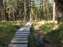
Ride up gillard forestry road till you reach the gravel take a left up the fire road there are exits all along this road depending on how far you want to ride up, there are numbers along the side I ride up to the number 7 which is about and hour for me, and jump on to a single track down. technical down hill
First added by RydingMountains on Aug 16, 2006. Last updated May 1, 2020. → add an update
Before you go
- Drinking water: unknown
- Lift service: unknown
- Night riding: unknown
- Pump track: unknown
- Restrooms: unknown
- Fat bike grooming: unknown
- E-bikes allowed: unknown
- Fee required: unknown
This trail information is user-generated. Help improve this information by suggesting a correction.
Driving down Pandosy/lakeshore, con't up to kettle valley at the top of the hill you will reach Gillard Forestry Rd. park at the bottom there.
System trails (2)


Loading reviews...View more