Frozen Head State Park Fire Tower Trail trail photo
See all photos (8)
×
User
Today
 
  |   Rate it:

Tags:
Level: Intermediate
Length: 10 mi (16.1 km)
Surface: Fire Road
Configuration: Out & Back
Elevation: +1,061/ -1,099 ft
Total: 6 riders
 

Mountain Biking Frozen Head State Park Fire Tower Trail

****   Add a review
#100 of 203 mountain bike trails in Tennessee
#5,740 in the world

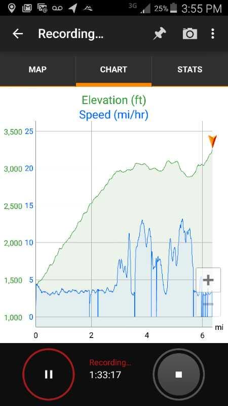
This trail has very limited technical portions. The real challenge to the trail is that the first 3 or so miles are uphill. The only breaks from climbing are small bridges that cross over creeks cut in the side of the mountain. These are typically about 15 to 20 feet wide. The grade isn't too bad, but it can really be taxing. About 3/4 of the way up, there are some large, loose rocks which come an a perfectly opportune time to force you off the bike. Once you get to the top of the climb, you run along a ridge with some nice roll to it. About two more miles out is the climb to the fire tower. It's a fairly steep, long climb. When you get to the top though, it's well worth it. You can actually climb up in the fire tower and get some great views. Directly down the backside of the mountain is Brushy Mountain State Penitentiary. Far in the distance to the east are some giant windmills which are cool to see. When you come down, there are two options for returning to the bottom. If you go the way you came, prepare for a high speed, bumpy ride to the bottom (it's the kind of ride that leaves your kidneys hurting from all of the jarring). The other option is, once you leave the fire tower, at the bottom of the hill, there is a trail that goes off to the left. If you take this trail, it becomes very narrow singletrack with a lot of technical cutbacks and places where the trail essentially drops out for a couple of feet or so. The trail is primarily for hiking, so there are a good number of areas with large roots, etc. This trail will put you out at Panther Branch and you can follow the trail back down to the road. Once on the road, follow it about a half mile to the three way stop and take a right back up to the campground.

First added by ductus on Sep 23, 2006. Last updated Apr 29, 2020. → add an update
Before you go
  • Drinking water: unknown
  • Lift service: unknown
  • Night riding: unknown
  • Pump track: unknown
  • Restrooms: unknown
  • Fat bike grooming: unknown
  • E-bikes allowed: unknown
  • Fee required: unknown
This trail information is user-generated. Help improve this information by suggesting a correction.
Getting there
From Wartburg, head east on highway 62 about two miles or so. There will be signs for Frozen Head State Park on the left. Turn left onto Flat Fork Road and follow it all the way to the park (the road ends in the park). Once in the park, you will pass the ranger station and welcome center on the right. If you follow the road about a half mile, you will come to a three way stop sign with one fork going across a bridge to the left. Take the left across the bridge and follow it up the hill to the campground. The road makes a clockwise loop starting left. When you get to the top of the loop, you will see the trailhead and a little parking area.


Frozen Head State Park Fire Tower Trail Trail map

Add to or improve this map // Share this map on your website

Local Info

Club Sponsor

-

Trail checkins

C-Lo (on Sep 12, 2021)
What's this?

Upcoming Events

None.
Add one

Trail conditions

Good (on Sep 12, 2021)
login to update

Camping & Lodging

Coming soon!

Frozen Head State Park Fire Tower Trail videos

Add a video
We don't have any videos of this trail yet. Add one here.

Mountain Bike Trails Near Wartburg, Tennessee

*****
| 12 mi

Add a review

Rating
 
Difficulty
 
Review

Reviews

    Loading reviews...

Rider questions