


This trail is roughly 30 miles with 5-6 of those miles above treeline. The first couple of legs of this ride are on the Colorado Trail (Copper to Camp Hale via Searle Pass and Kokomo Pass), where it's almost all singletrack, while the return is mostly on 4x4 road, double track, and paved bike path.
Start by finding your way into the heart of the Copper Village and look for the chairlift named American Eagle. The start of the trail is just to the right of the lift (before American Flyer) and is a dirt road that you'll see switchback up the hillside. After the first switchback, you'll see a rock painted white with the Colorado Trail symbol painted on it and a singletrack next to it. Continue to follow this trail as it meanders and switchbacks up Copper Mountain. There are many side trails that cut off the CO trail through this section, but the CO trail is clearly marked. This part of the trail has been heavily used by horses, but don't let the leftovers deter you, it'll quickly be over and the real riding will begin.
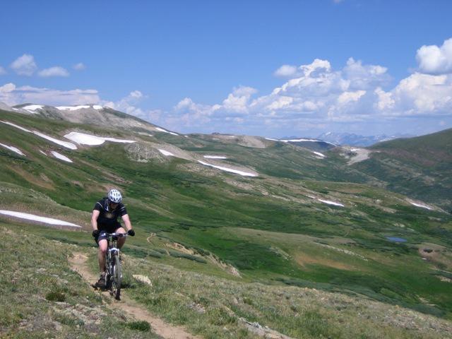
You'll eventually come out at a stream (Guller Ck) with a crossing and a long open valley. The horse traffic should be over, and you'll continue up the valley to above treeline. You'll top out after a bit of hike-a-bike at Searle Pass (12,035ft, 7mi).
Before you go beyond this point, make sure the CO weather is on your side. You've still got over 3 miles to Kokomo Pass (all above treeline) and on the return trip Ptarmigan Pass ( at treeline). Neither are good places to be in a thunderstorm.
If it all looks good, continue across the vast alpine tundra to Kokomo Pass (12,011 ft, 10 mi). This is arguably the best tundra riding in all of Colorado (similar to Monarch Crest, but without all the people).
Once you reach Kokomo Pass, the fun begins. You've got 3,000 vertical feet to drop to reach Camp Hale. The downhill has got just about everything you could think of: rolling singletrack, fast double track, switchbacks, loose technical sections, etc.
You'll reach the forest road at the valley floor. Take a right to contour around the bottom of the mountain through historic Camp Hale (home of the 10th Mountain Division during WWII). At the north end of Camp Hale, you'll see the 4x4 road (Ptarmigan Pass) heading up to the right (east). Continue up this road, for what will seem like an eternity until you top out at Ptarmigan Pass (11,772 ft, 23.4mi).
From the top of Ptarmigan Pass, you should be able to see I-70 and Vail Pass to the NE. Follow the 4x4 road as it drops off the pass for less than a mile to where it reaches a saddle on the ridge. The road will drop off the ridge to the left (west), but you want to take the small trail that drops off the ridge to the right (east). This is Wilder Gulch and it's all downhill from here.
Continue down Wilder Gulch until it reaches I-70. There are some very swampy spots through here, so be aware and stay on the trail! At the end of the valley, jump on the paved bike path and cruise back to your car.

Loading reviews...View more