Home > Mountain Bikes > Mountain Bike Reviews
Mountain Bike Reviews
Wondering what mountain bike to buy next? If you’re in the market for your first bike or n+1st bike, research is key! We’re here to help with mountain bike reviews on all the top brands and ride styles including gravel, trail and enduro.
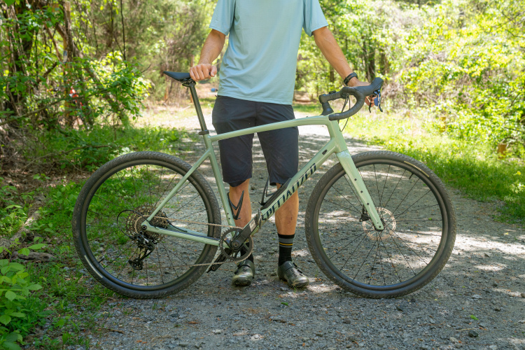
The Specialized Diverge 4 Comp Alloy gravel bike features front suspension, wide tire clearance, and versatile storage options.
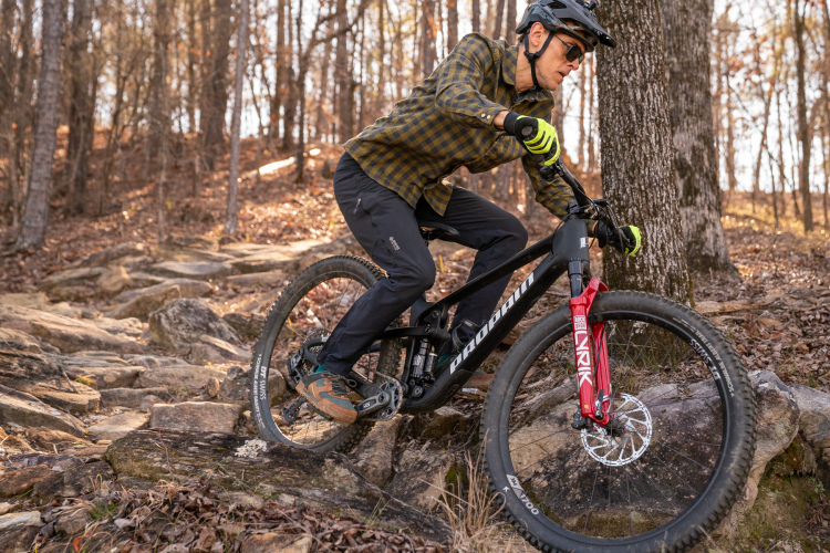
The Propain Hugene is a value-priced 130mm travel trail bike that climbs and descends in a business-like manner.
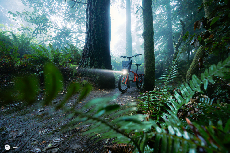
The Brompton Electric G Line combines portability and off-road capability, making it a versatile option for urban commuting and light trail adventures.
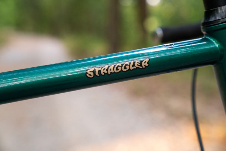
The updated Surly Straggler gravel bike blends quirky charm with modern versatility, making it a fun bike for riding everywhere, from pavement to singletrack.
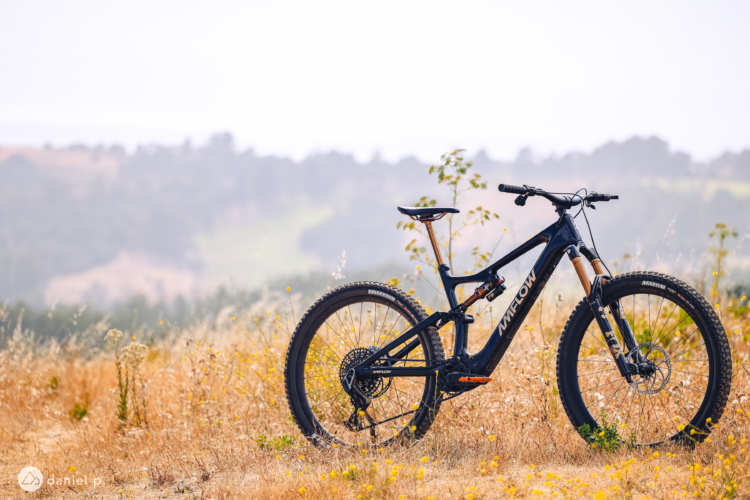
The Amflow PL Carbon Pro eMTB redefines performance with its innovative Avinox M1 drive system, offering seamless integration and trail-ready capability for serious riders.
The Specialized Turbo Levo 4 eMTB delivers an incredibly natural ride feel that makes tackling tech trails and steep climbs a joy.
The 2025 Niner ORE 9 RDO is an all-new, lightweight gravel bike designed for riding wherever you want to go.
The Canfield Yelli Screamy hardtail mountain bike handles technical trails with ease and is designed to last.
Mountain bikers will be stoked for the steel frame with dropper post routing, clearance for wide tires, UDH compatibility, and mounts for bottles, racks, and fenders on the State 4130 All-Road gravel bike.
The 2024 Rocky Mountain Element cross-country mountain bike cuts a similar silhouette to the old one, but does it ride any differently? We put it to the test.
The Stumpjumper 15 brings new GENIE shock technology to the venerable trail bike, which sees more travel and further refinements.
The Rocky Mountain Altitude enduro bike has a totally new suspension layout, and we put it to the test with a full season of riding.
The new Knolly Fugitive blends mid-travel and a solid build spec for all-around trail bike fun, but how does it perform?
I’m never going to threaten the podium at an enduro race — but the Transition Sentinel made me feel as if I could, and ride as if I should.
The Trek Top Fuel is a short-travel mountain bike that tries to do a lot of things, though I found it's really an XC bike at heart.
The Cannondale Habit trail bike features 140/130mm of front/rear suspension travel and boasts a simple yet refined design.
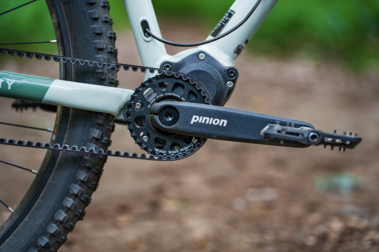
The Priority 600HXT is a solid, low-maintenance, belt-driven hardtail mountain bike with an impressive build and thumb-tap gearbox shifting.
I modified my Santa Cruz Tallboy to make it the ultimate bike for BC Bike Race. And for the most part, everything worked out.
The Trek Marlin+ 8 electric hardtail mountain bike is singletrack-worthy and a fun commuter bike too.
The Mongoose Switchback Expert is an entry-level hardtail mountain bike that's available at Dick's Sporting Goods.
The Enve MOG is a versatile gravel bike that fits wide tires and is dropper post ready for tackling steep and rough rides.
The new Ari Nebo Peak electric mountain bike is lightweight enough to feel playful at the park and on the trail.
The second generation Privateer 141 all-mountain bike has 150/141mm of suspension travel front/rear with a seat stay flip chip for mixing wheels.
The Marin Rift Zone XR is an aluminum trail bike with a quality build that includes a SRAM GX Eagle Transmission drivetrain.
The Giant Trance X Advance Pro SE trail bike features all the electronic bells and whistles paired with a carbon frame.
A Sedona hot lap on the new Transition Spur suggests this is a bike that can punch above its weight.
The 2024 Norco Optic 125mm trail bike gets a high pivot and idler pulley from its big siblings and makes a case for the suspension system on shorter-travel bikes.
The Mullet Peacemaker is a mixed-wheel, 160/150mm all-mountain bike with a simple, well-executed design.
We rode the all-new Norco Sight on some of Sedona's best trails for a day. Here's what to expect from the new high-pivot bike in its mixed-wheel form.
The 2024 Liv Pique Advanced XC mountain bike adds travel, drops weight, and improves performance. After a long-term test in Colorado, this is our review.
The latest Rocky Mountain Instinct trail bike is a versatile, do-everything bike and technical trail smashers will love it most.
The Revel Rascal got a lot right with the first release, and V2 nearly perfects this winning trail bike formula.
The Pivot Switchblade is one of the brand's best-selling bikes which adds to the pressure of trying to make a great bike even greater.
The Canyon Spectral CF 8 K.I.S. is a unique carbon fiber mountain bike with a mixed-wheel layout, coil shock, and a SRAM GX AXS drivetrain, all for under $5,000.
The Liv Intrigue LT Advanced Pro enduro bike offers outstanding performance, unmatched versatility, and the latest tech that will impress even the toughest critics.
The latest GT Sensor Comp promises a fun, short travel trail bike at an enticing price, but does the ride deliver?
The Norco Sight straddles the line between trail and enduro bikes giving riders plenty of options for the weekend.
The Yeti SB135 is a highly capable premium trail bike that makes both climbs and descents fast and fun.
The Specialized Epic EVO nudges the racy XC bike into trail territory, making it the perfect choice for the BikeTransAlp multi-day stage race.