I grew up in central Pennsylvania, but I always envisioned myself leaving and moving either out west somewhere or to northern New England—two places that I thought had more to offer for an independent, outdoorsy woman such as myself. It wasn’t until I began to travel after high school and into my college years that I began to truly appreciate my home. After graduating from Penn State, fate made it an easy decision to stay, and in the time since, I’ve only come to discover more awesome things about this place that I’d never even known about in all the time I’d spent here–the superb mountain biking being one of them.
It’s hard to pick just five trails that stand out as my favorites or the best, and the five areas I’ve chosen are listed in no particular order. Rather, they are simply distinctly different spots, all of which showcase what mountain biking in central Pennsylvania is all about.

Tussey Mountain is located on the outskirts of State College, PA, a town most notable as the home of Penn State University. But it’s also a town full of great craft brews, good food, and jammin’ live music that is surrounded by Rothrock State Forest. Rothrock boasts a couple hundred thousand acres of mountainous woods that are criss-crossed by countless miles of singletrack connected by a network of gravel roads. Though there are a few trails designated for hiking only (most of these are long-distance thru-hiking trails), most are multi-use, and are becoming ever more friendly to mountain bikers.
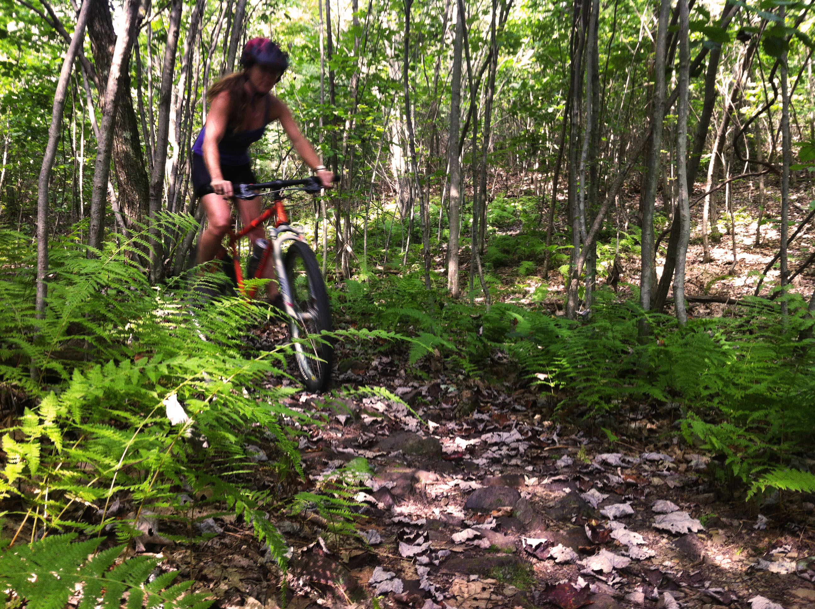
The Tussey Mountain area of the State Forest is just a few minutes drive from the town of Boalsburg, one of the smaller communities surrounding State College. Tussey Mountain Trail, which runs along the ridgetop that is its namesake, is the must-ride. After a rather gradual climb up to the top, the rocky path follows the ridge for several miles, offering stellar views of the ridge and valley landscape of the region. The trail itself is moderately technical, strewn with rock gardens and fun log-overs, and it’s a great place to hone skills while enjoying the scenery. Almost 10 years ago, a wildfire ripped through part of this area, creating an open landscape very atypical of Pennsylvania ridgetops. By now, underbrush has begun to fill in the burn zone, but the otherworldly vibe still remains.

2. Coopers Gap

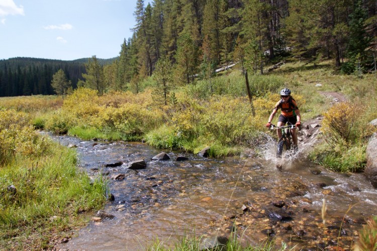
Just across the mountain from Tussey lies Coopers Gap, another section of Rothrock State Forest. The Coopers Gap area offers lots of variety and many options for shorter or longer loops. There’s a little bit of everything–rocks, roots, stream crossings, bridges, mountaintops, and valleys. There are trails that are flowy and trails that aren’t so much. Some are steep, others are gradual. Most are moderately technical, but some are hardly at all, and others are basically a random pile of rocks that is somehow called a trail. Riding in Coopers Gap will take you through fields and deep woods, rhododendron-filled valleys and fern-strewn meadows–all within a couple hours’ ride.
Coopers is one of those places where I never get bored. There are trails there I have yet to explore, and even the same trails can change so much depending on the time of year and conditions. I do have my go-to loop, though–it’s about 10 miles, isn’t overly difficult but is still a great workout, incorporates a little bit of almost everything that Coopers Gap has to offer, and is doable in two hours or so if time is of the essence.
The loop includes a gradual descent on Shittaka and Sass-xx Trails, then a switchbacked, winding climb to the top of the ridge on Deer Tick. Jump on the aptly-named Beautiful Trail to follow the ridgeline back towards the car, and finish via Chicken Peter Trail.
If you ride in Rothrock, you’ll definitely want a map. The best map for planning a ride is by far the Purple Lizard Map–comprehensive, accurate, waterproof, and created by local mountain biker Mike Hermann. Here’s where you can get one. Looking to rent a bike, buy that piece of gear you forgot, or soak up some more local knowledge? Check out Freeze Thaw Cycles in downtown State College. Across the street, you’ll find a great beer selection at Zeno’s Pub.

The Allegrippis Trail System was formed in 2009, and it includes 33-plus miles of smooth, fast, and flowy singletrack. The trails are located on the hills above Raystown Lake, south of Huntingdon, PA, and have turned the small, rural town into a mountain biking mecca with a burgeoning local community of riders and advocates that make up the Raystown Mountain Bicycling Association. It is also the site of Dirt Rag Dirt Fest, an annual mountain biking event that draws several thousand people from around the country for a weekend of expos, clinics, camping, live music, group rides, and of course, the enjoyment of the now-nationally-known trails.
The trails are organized in a series of stacked loops with a difficulty rating system much like that used at ski resorts–green is the easiest, black is the hardest, and blue is in between. Difficulty is not necessarily determined by the trail conditions themselves, but rather how far they are from the parking lot, and how much of a climb there is out in case of injury or exhaustion. Green trails don’t wander far from the vehicles, but the black trails will take you to far-reaching peninsulas and vistas. None of the climbs are too steep, and none of the trails are too technical. It’s a totally different experience than the one you’ll get in Rothrock, but an equally great one.
Ample camping is available during the warmer months, both on Army Corps land and private campgrounds. I highly recommend Susquehannock, which is literally located in the middle of the trails. If camping isn’t really your speed, check out the Adventure Suites above Rothrock Outfitters (RRO) in downtown Huntingdon. They offer bike-friendly lodging just down the street from the best restaurant and bar in town, Boxer’s Cafe.

For more information on the trails and updated conditions, check out the Allegrippis Trails website. There are maps at some trail intersections, and they are also available online or at RRO.
4. Terrace Mountain Trail
Terrace Mountain Trail (TMT) is located on the eastern side of Raystown Lake, across the water from Allegrippis. The 27-mile-long trail runs nearly the entire length of the lake, winding up and down the mountainside. It’s great as an out-and-back or overnight, or as part of a longer cross-style ride. Last year, an Adirondack shelter was constructed along the trail, offering a cool option for bikepacking accomodations. The trail was also recently redone, as it had been neglected and nearly nonexistent in some spots, and there is ongoing work being done to improve some sections. Most of it is now complete, however, and ready to ride. I haven’t yet gotten to explore the TMT as much as I’d like, and I’m looking forward to some overnight trips on it this spring.

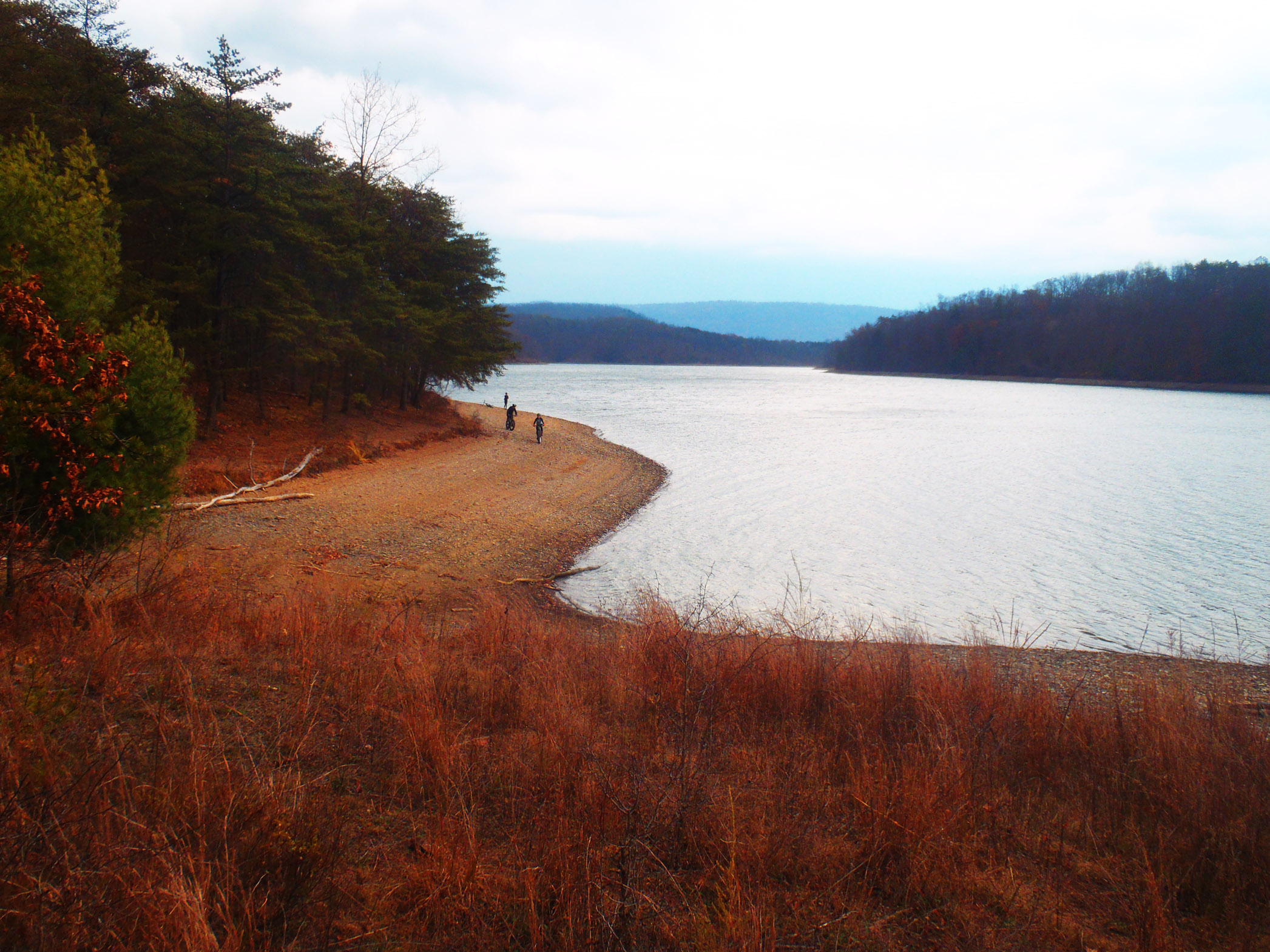
5. Raystown Lake Shoreline
This is the most unique of the bunch–and the most illusive, as it’s only an option a few months out of the year. Each fall, the Army Corps of Engineers, who own and manage the lake and the land around it, reduce the lake level–sometimes by only a couple feet, sometimes by up to about 9 feet–and don’t fill it back up to normal levels until early spring. This opens up more than 100 miles of shoreline that is usually covered by water. Much of it is unrideable due to steep cliff faces or too many downed trees, but the parts of it that are passable are incredible.
The surface ranges from large, chunky rocks to fine sand and mud. Ghostly tree stumps that are usually at the bottom of the lake become exposed, and the landscape makes it easy to believe you are on some remote coastline far from any civilization.
Both the Terrace Mountain Trail and Raystown Shoreline are a bit more off-the-beaten-path, so stop by Rothrock Outfitters to get the inside scoop on where exactly to go to maximize your experience and get the latest update on conditions.
There are plenty of trails and areas that I didn’t mention, and I’m always discovering new places to ride. My list of favorites is always evolving–that’s the beauty of it!
Your Turn: Those of you who have ridden in central PA: what trails have stood out to you?