


For this year’s annual end of the year bike trip we decided to do a combination of camping in Southwestern Utah and condo living in Park City. For the first half of the trip we set up camp at Cedar Breaks National Monument’s campground near Brian Head.
Our plan for this portion of the trip was to revisit two rides we did years ago: a portion of the Virgin River Rim trail and then Bunker Creek’s Right Fork. Our third ride in this area would be Thunder Mountain in Red Canyon.
Virgin River Rim Trail / Dyke Trail / Navajo Lake Trail
When we rode here about 5 years ago this portion of the Virgin River Rim trail had me hyperventilating every 5 minutes. Perhaps I exaggerate, but it was NOT an easy climb for me. This time around was much different, and I was able to actually enjoy every bit of the ride.
We like to start from the Te-Ah campground (there’s a very obvious day parking area right by the lake just before you get to the campground) and ride up. After a few miles of mostly gentle climbing, you’ll reach a false summit. From here, there’s a section of really fun (but sketchy) downhill riding before one last push up to the top and the intersection with the Dyke trail. Along the way, you’ll see other trail spurs that head down to the various campgrounds around Navajo Lake.

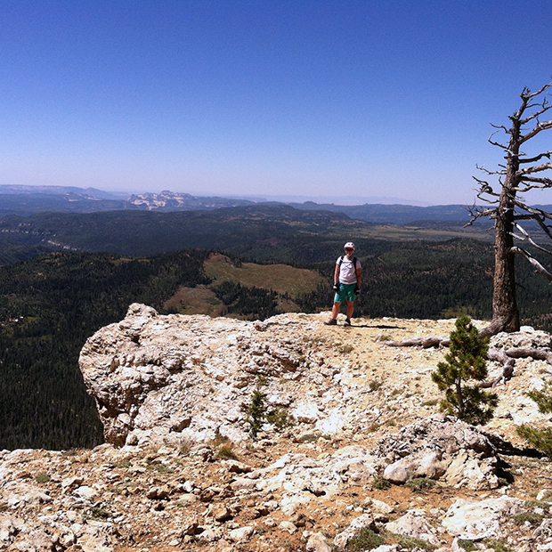
The views from the Rim Trail’s overlook are stunning. After this overlook, you’ll intersect with the Dyke Trail and enjoy a few more miles of downhill through dark woods with lots of fun, tight trees. At the final fork, turn right and bike parallel to the road for about 1/2 mile before dropping down and crossing the road onto the Navajo Lake Trail. This 5-mile trail loops around the lake and is a great addition to your ride. If you parked in the day parking area just below Te-Ah, you’ll end right at your car.
My favorite part of this section of the ride is riding through the lava flow. The path isn’t technical through here, but be careful: if you DO fall on that rock, it’s going to hurt!


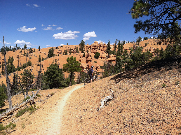
Thunder Mountain Trail, Red Canyon
The BF had started this trail one time before, many years ago. He had to turn back because of rain, and always wanted to finish it. After all, it’s considered one of the best trails in Utah! We chose to park at the paved parking area by the road leading to Coyote Hollow. To find this parking area, drive about 8 miles up the Red Canyon highway leading to Bryce Canyons National Park. Once the road levels out at a steppe, look for a sign for “Fremont ATV trail” and a parking area with a bathroom on the right. From there, we biked about 2 miles down the gravel road to the trail head.
The first third of Thunder Mountain was fun: it alternates between singletrack climbs and descents, and quickly you’ll see the pattern emerge. This makes it easy to adjust your fork in advance.

The next portion of the trail, which includes the 1/4 mile ride along the “fin,” is gorgeous. The views and hoodoos surrounding you are just fantastic. However, the switchbacks in this section of the trail become very steep and exposed. When we were there they were also full of fist-sized rubble, making riding them very difficult and sketchy.

The last few miles are a blast! Once we were finally down from the ridge, we spent the last two miles just flying down a singletrack trail, crossing washes, and surfing over rubble. The trail definitely ends on a high note… until the 6-mile bike path ride back to the car begins!
Bunker Creek, Right Fork
Our final ride of the Southwest Utah portion of our trip was on Bunker Creek, Right Fork. For this ride we like to call upon Georg’s Ski Shop in Brian Head for a shuttle ride. The cost for two people is $25 per person, but it’s well-worth it. We do the “reverse” shuttle, leaving our car at the end of the ride and getting the shuttle back up to the top of Brian Head Peak.
I don’t remember much about the last time we did this ride. I remember sheep and cows, and lots of scary downhill. I know this time I rode way more than I did before, but for many early intermediate riders this trail may be a bit too much. Still, even if you walk the really hard parts, you’ll enjoy the parts you do ride!
This ride is almost all downhill; a full 12 miles of riding involves maybe one mile total of climbing. After a very short but steep start on the path to the Sidney Peaks trail, the path levels out. The views on this portion of the trail look out over southern Utah and show meadows, forests, and even some red rock sections. It’s beautiful!

This portion of the ride has a few rocky and rooty sections, but they’re short. At the Bunker Creek junction we take the Right Fork (which is on the left). It’s plenty technical, and I hear the Left Fork is even harder. I have no desire to head down that one!
From here it’s just a full-on downhill for several miles through the woods. This section of the trail has long rocky sections, and sections filled with roots and tight trees too. It’s important to be aware of the trail at all times so that you don’t suddenly come around a corner and hit a rock that stops your bike… but not you. I mean, that’s just a hypothetical of course.

The trail is so fun and so fast that this is the only shot we took once we hit Bunker Creek. After miles of singletrack you’ll come to a junction and a sign pointing left to Panguitch Lake. Follow the doubletrack to your left. After a short climb, you’ll be flying down this too! Even the doubletrack here is fun, with just enough rocks to keep you on your toes. At the end of the doubletrack, turn left and ride the very short distance down the highway to your car.
Even with one crash in there somewhere our first three rides of the trip were all superb. There was almost no blood, and there were no bike issues. I’d rank the Virgin River Rim trail ride as #1, Bunker Creek #2, and Thunder Mountain #3 (this isn’t based on views, just on riding alone). So far we’d covered about 41 miles of trail.
Cedar Breaks National Monument was a great base camp for this trip. Even though our Red Canyon ride was about an hour’s drive from there, the other two rides were closer by. FYI, this campground has free showers.
Stay tuned for the second half of our trip: Park City, Utah!


