It’s 5:54am as I slide two neatly-folded bills down the cash box before sauntering down the aisle to locate a seat towards the back of the Mount Hood Express. Surely, no city bus route has garnered so much recent popularity (for better or worse), so it’s best to get it in early. A few others on dawn patrol stumble aboard, steadying saddles in one hand while fumbling for pocket change in the other. Clink, clink! The price of a shuttle never sounded so good.
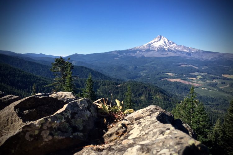
Thirty minutes, 4,000 feet in elevation, and five cinnamon bears later, we’re standing in the shadows of Oregon’s loftiest peak outside Timberline, the only North American resort with year-round lift service for snow goers, thanks to one of 12 glaciers adorning Mount Hood. As such, it’s the only place on this continent where you can shred brown and white pow (okay, glacial pow) on a mid-summer day in one place!

The Ride
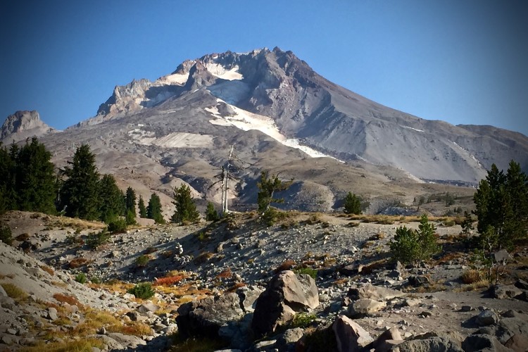
The Timberline to Town (T2T) Trail begins at approximately 6,000 feet above sea level after a short, 100-yard climb west through the Timberline Lodge parking lot. Just a few years back, the first five miles of the Timberline Trail were nothing more than an unmaintained, uninspiring road of sorts coursing down the western slope, until mountain bike activists came through carving out the wickedly-windy descent that now connects to the lower trail system.
The first five miles of Timberline snakes down the west bank of Mount Hood, diving through alpine forest over volcanic pumice that, although it tends to fall victim to blow out during the mid to late summer, lends itself to good drainage and hero conditions in early spring or when rain has swept through the day before. Here, Timberline is chock-full of reverse grades and tight corners, keeping speed in check as it lowers you line upon line.

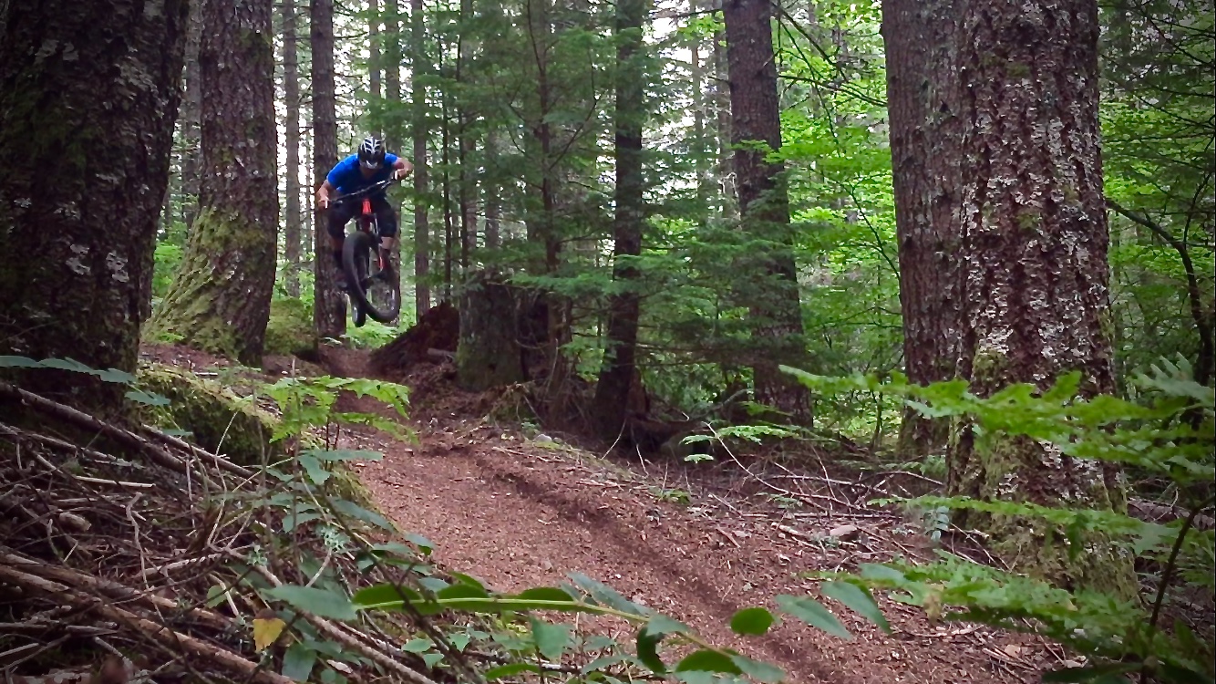
Intersecting with the Crosstown Trail just outside the town of Government Camp, Timberline takes on a completely new demeanor with a wider track and stretches of straight open trail as you cross over to the lush and mossy temperate rainforest. The first half of Crosstown consists of rockier terrain, giving rise to many an opportunity to kick a little air for those willing to seek it. Eventually it gives way to a smoother surface as you approach the third and final leg of T2T on the Pioneer Bridle Trail.
The eight-mile stretch on Pioneer Bridle Trail extends from the Glacier View Sno-park (a parking option, see below) all the way back to Rhododendron, OR. In the first four miles of this, the last section, you will likely encounter some of the highest-speed descents of T2T, just after earning them on a series of small climbs. The trail then brings you out to Highway 26 where you cross to pick it up again for the last four, easy-pedaling miles on singletrack, paralleling the highway.

Parking and Shuttle Info
Rhododendron, OR, the “Town” in this report, is one of a handful of resort colonies situated along the beautiful Mount Hood Corridor byway (U.S. Route 26) and is the best option for parking if you’re shuttling by bus. Please respect local merchants by either parking at Mount Hood Adventures or, if you have a Northwest Forest Pass, the Tollgate campground just a half mile east of town. With growing popularity and limited space on the Mount Hood Express and its bike trailer, and to assure a seat on weekends, it’s worth the 3.5-mile road ride afterwards to park at the bus stop just before Rhododendron, located across from Thriftway in Welches, OR. The Mount Hood Express accomodates bikes with its 25-foot trailer, and the bus schedule can be found here.
Ride Options
Of course, riders aren’t obligated to bus to Timberline, as the trail is open to two-way hiker and biker traffic or, if you want to shuttle with your own rigs, the road is paved to the top. Alternatively, bail-out options with parking are available where the singletrack crosses Hwy 26, at Glacier View Sno-park, and in Government Camp.
For the best bang for your buck, a $5/day bus pass purchased from the Mount Hood Express driver gets you all the shuttles you can fit into one day. Catch the earliest bus (5:54a) from Rhododendron to Timberline for a full T2T run, putting you back in town and on time for the 8:24a pick up. In order to catch a third bus, on the second run take a left at the Crosstown trailhead and ride into Government Camp for a 10:13a shuttle back to the top. A third session (second full lap) puts you back at your car in town by 12:30p. That’s a whopping 40 miles of singletrack and 10,600 feet of descending in 6 hours for less than the cost of a venti mocha frappuccino.

The Timberline to Town Trail is a must-do for anyone visiting Portland, Southwest Washington, or Hood River, OR. Keep the family entertained while you get your fix with a host of summer activities at the Timberline Lodge or Ski Bowl (just down the street) and, when you’re done, swing by the Columbia River and go get lost in The Gorge.
StumpTownRider’s Post Bike Bite & Beverage
The following should fit your post T2T needs: Bunsen Brewer (Sandy, OR), Wraptitude (Welches, OR), Red Shed Public House (Sandy, OR), or Skyway Bar & Grill (Zigzag, OR).
Getting There
From Portland, drive east on Hwy 26 to Rhododendron, OR. From Hood River, head south on Hwy 35, merging onto Hwy 26. Continue west on 26 to Rhododendron.
Timberline to Town
- Type: Downhill, point-to-point
- Difficulty: Intermediate
- Miles: 17
- Elevation loss: 4,387ft

The Hood Report is a series of ride reports on trails in the Mount Hood region located along the Mount Hood corridor through the Hood River Valley along U.S. Route 26 in north central Oregon. Read our introduction and overview on Hood-area riding here.