singletracks is mountain biking
 
Trail is --
 
  
Avg Rating: 4 trail reviews
Difficulty: Beginner bike trail - Beginner
Length: 4 miles Global Rank: #4151
Tread: Singletrack Configuration: Network
Ridden: 32 Wishlist: 22
0 trail check-ins Climb // Descend
+700 // -800 feet
Average Speed: 7.2 mph Average Time: 2hr 19min


Directions
To view directions to High Plains Trail mountain bike trail, please login. If you don't have an account, sign up for a free account - it only takes a minute.

Description
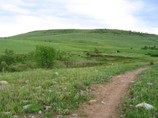
This is a new section of singletrack that flows across the high plains West of Superior that opened this Spring (2007). There's nothing technical as the trail rolls through the plains through fields of prairie grass, wild flowers, scattered rocks on the trail, while offering great unobstructed views of the Flatirons, and occasionally Longs Peak, and some of the Indian Peaks.


The cool part about this trail is that it connects the Coalton Trail (accessed off McCaslin Blvd. in Superior) to the Marshal Mesa/Community Ditch trails making for a long, non-technical ride that has occasional short, yet steep and quick climbs, a cool "drop-off" at the bridge crossing over Community Ditch itself, as well some fast sections of newly made singletrack (which usually runs adjacent to the gravel trail).


Start at the Coalton Trailhead (in Superior), head West. The trail travels South for a bit after a quick steep climb, and eventually hooks up with the High Plains Trail. Take the downhill through the plains, crossing over several bridges, and rolling its way toward the Greenbelt Plateau Trail. Head North on the Greenbelt Plateau trail. Eventually you will come to a set of stairs, head down them, and take this fast track towards the cool drop-off at the bridge crossing over the Community Ditch itself. Go West immediately after crossing the bridge, and head towards the new sections of the Marshal Mesa trail. Ride the trail through the trees, cacti, rocks, that are scattered over this area. Continue East as the trail eventually turns away from the mountains, and meets up with the Community Ditch Trail. Continue heading East as you ride along the top of the plains. This part of the Marshal Mesa trail ends at S. 66th St. Turn around and head back the way you came, ending back at the Coalton Trailhead.

added by Jurassic Gramcounter on May 30, 2007

Trail Reviews   [Add a review]

dr_albright on June 20, 2012
0 out of 0 readers found this useful
 
Review: Short, quick, and relatively easy. A few small sections of rocks, but nothing to worry about. Good place for beginners how to pedal over small obstacles. You can connect to many of the Superior- and Boulder-area trails from here.

Was this Review helpful? Yes | No
 
JohnsXCbike on May 25, 2009
0 out of 0 readers found this useful
 
Review: Great easy ride close to home, nice not having to drive 30-45 minutes to get to trails in the mountains. This trail can be linked to other trails on the West side of Highway 93. Last ride I did about 14 miles on the trails. Its a faily easy ride if you don't want to battle with the big rocks or high altitudes of other trails in the mountains. All around fun and not very strenuous.* Review edited 5/31/2009

* Review edited 5/31/2009

Was this Review helpful? Yes | No
 
steve32300 on May 4, 2008
0 out of 0 readers found this useful
 
Review: If your familliar with the coaltin trail and ride it,then this addition will be a good thing for you.I myself used the coaltin trail and when they put this in we just had to go back and check it out.Thre is'nt any technical riding or challenging climbs,but if your exhausted from too much riding and need still need to get out and pedal then this is'nt a bad place.

Similar Trail: standley lake.

Was this Review helpful? Yes | No
 
Someonelse on August 20, 2007
0 out of 0 readers found this useful
 
Review: I rode this trail this morning and I have to say it was a pretty good workout. Especially having just started mountain biking a couple of weeks ago. I started out on the Coalton trailhead, to High Plains, to Greenbelt Plateau, and west on Community Ditch to Eldorado Springs. Nothing special about the last two other than adding mileage but I really enjoyed High Plains as it provided a good mix of climbs and downhills both ways as well as a killer view! I know this is a beginner trail and being a beginner myself this was tough to conquer there and back taking a little over 3.5 hours. This run will be good practice for me for now.

Similar Trail: Marshal Mesa Area Trails

Was this Review helpful? Yes | No
 

Recommendations

Monarch Crest Trail (100%)
Palmer Trail / Section 16 (100%)
South Saint Vrain (100%)
Jones Downhill (100%)
Buckhorn Loop (50%)


Colorado Outdoor Lists


Copyright 2013 Blue Spruce Ventures LLC | Decatur, GA  
singletracks.com is yet another slick Review App