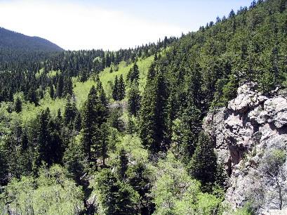
(NB: my odometer was acting funny on this trip, so take my distance measurements as estimates.) You can ride this loop clockwise or counterclockwise; I recommend going counterclockwise to take advantage of the Snowslide Trail downhill. Starting from the bottom of the Snowslide trail, ride up thru the recreation area to the trailhead for the Cisneros trail, or just ride thru the group campground at the end of the road, which also will get you onto the Cisneros. Begin climbing. I'm not big on grunting uphill, and I'm even less thrilled about pushing my bike up a trail. While it is possible to ride up the Cisneros if you are a man of steel, most people will probably end up pushing. And pushing. And pushing. By the time I got to the top of the trail I think I pushed a good three miles or more. Yuck. There is a steep section in the middle that goes on for a couple miles with lots of altitude gain. Then, after cresting the ridge there is a very pleasant mile and a half or so of gentle uphill thru a meadow area. Then, you encounter a steeper and more heavily bouldered trail that will often force you off the saddle. After picking up nearly three thousand vertical feet in about nine miles or so you will come to the Greenhorn Mountain Rd (FR369). Take a left (south) and go about a mile and a half till you see the sign for the Snowslide Trail. Go to the left (east) uphill till you finally crest out at the top. You probably have pedaled close to eleven miles to get to that point. The views are great. To the north you have a clear view of Pikeís Peak. To the northeast you will see the city of Pueblo. Now comes the payoff. The downhill portion of Snowslide Trail is rocky, steep, narrow, twisting, root infested, and challenging. In other words, a *lot* of fun. It took nearly eleven miles of uphill to get to the top and you will get to the bottom in about four miles. Get it? Steep. Not far from the top is a nasty, technical section. The hardcore riders will be grinning; everybody else will be dreading what is to come. Don't worry, it only lasts a hundred yards or so. After that the trail is mostly rideable by anyone with good technical skills. What a blast! Note that near the bottom the trail forks. Go left if you parked in the recreation area; go right if you parked on the highway. Picking a rating for this trail was difficult to me. As I was pushing my way up the Cisneros, the number kept decreasing, but by the time I got to the bottom of the Snowslide Trail my rating jumped back up. If you don't mind long uphills then you probably will feel it is worth a try. Oh, if you don't want to push your way up the Cisneros, and you have a ground crew, you could just have them drive you to the top of Snowslide.


Snowslide Trail isn't worth a velvet painting of a whale and a dolphin getting it on. It is made up of huge rocks that have been churned up by motorcycles. I wouldn't want to go up or down it. Cisneros trail is awesome. It's fast both up and down. I had a a blast on it. Do an out and back. Skip Snowslide.
| ThankI had high hopes for this ride, but was ultimately disappointed. Much of the trail is wide enough for my minivan--to call it singletrack would be a huge stretch. The climb is painful enough that the downhill better provide a huge payoff--in my estimation, it fell short. The Wet Mountains are beautiful, but the trail is heavily wooded throughout, so you never really get the great views.* Review edited 9/28/2011
| Thank